The STs* of PostGIS

* saints?
* spatial types?


@tkardi
Tõnis Kärdi
LonLat OÜ / UEC OÜ
tonis.kardi@gmail.com
https://tkardi.github.io/
preso/
balticgit-2022/

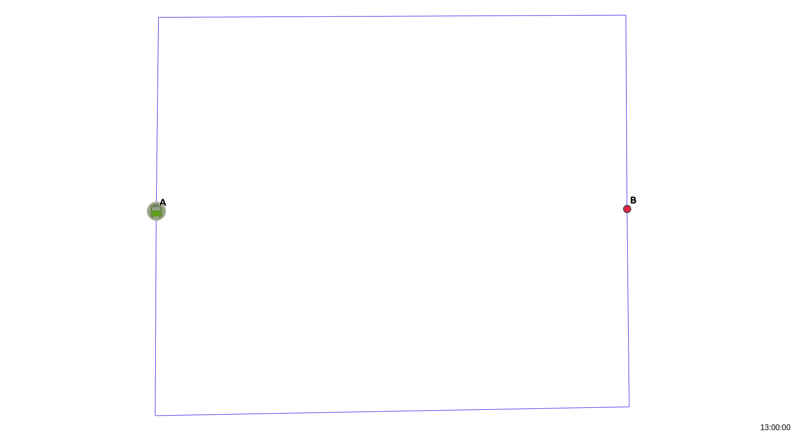
where's that bus at?

(supposedly)
On a cold winter evening some 5 years ago ...
Estimate real-time locations based on GTFS* !
(data by the Estonian Road Administration)


* - The General Transit Feed Specification
https://developers.google.com/transit/gtfs/
So imagine a bus route like ...
length: ~ 3.5 km
Based on current time calculate fraction of time between trip start and end and then st_lineinterpolatepoint the same amount
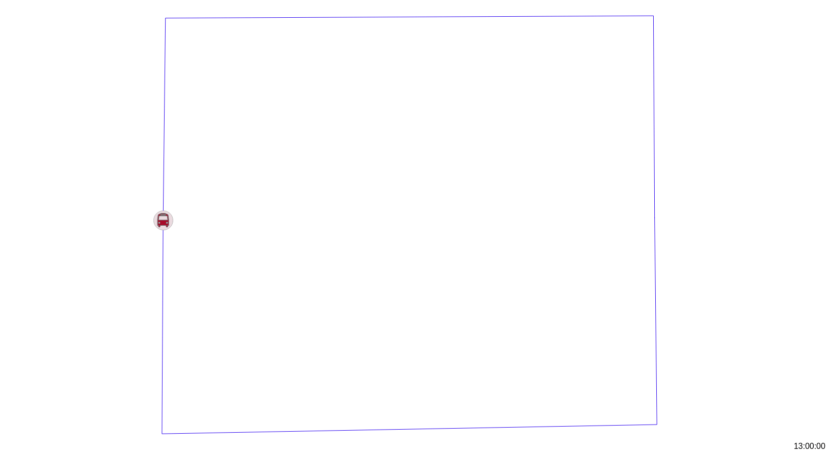
length: ~ 3.5 km, total time: 2 minutes
Cool!
(but with intermediate stops this bus will never be on time)
Consider trip legs of appr. the same distance...
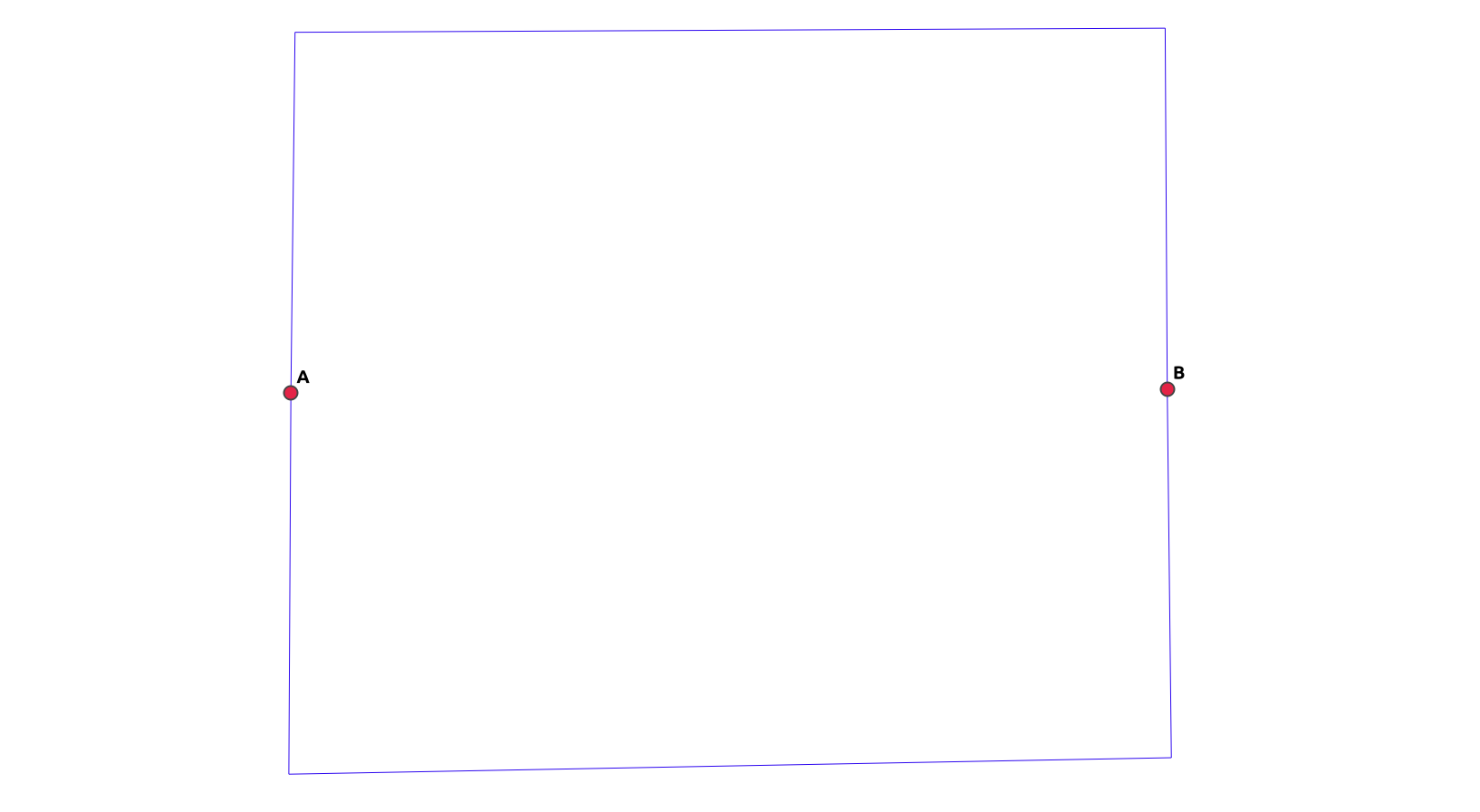
A to B: 1.8 km, B to A: 1.7 km
... but very different travel times
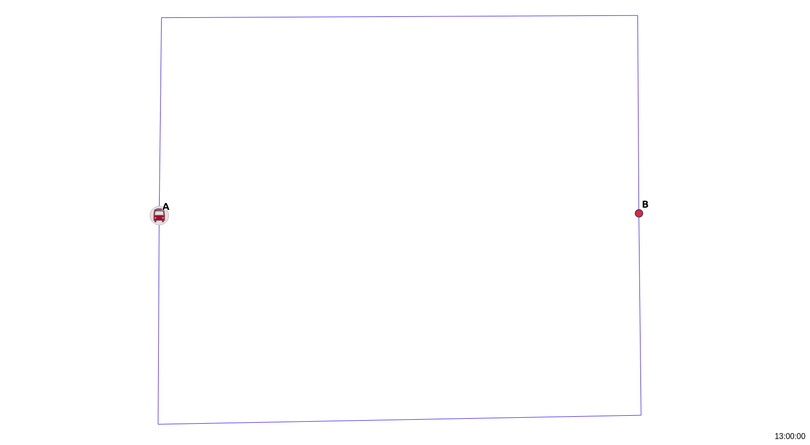
A to B: 30 secs, B to A: 90 secs
But how are passangers supposed to get on and off?
(add impedance to traveltime at stops)
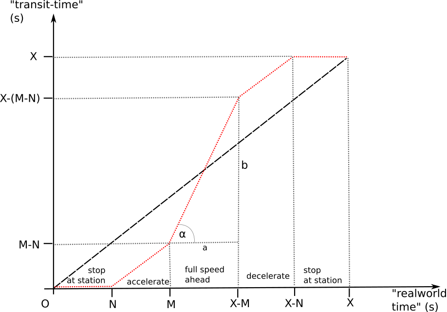
Adding acceleration/deceleration to transit location calculation.
(see here for details)
accelerate / decelarate: 8 secs, stop 3 + 3 secs
Red: interpolate whole trip. Blue: interpolate using stops. Green: interpolate using stops and impeded time
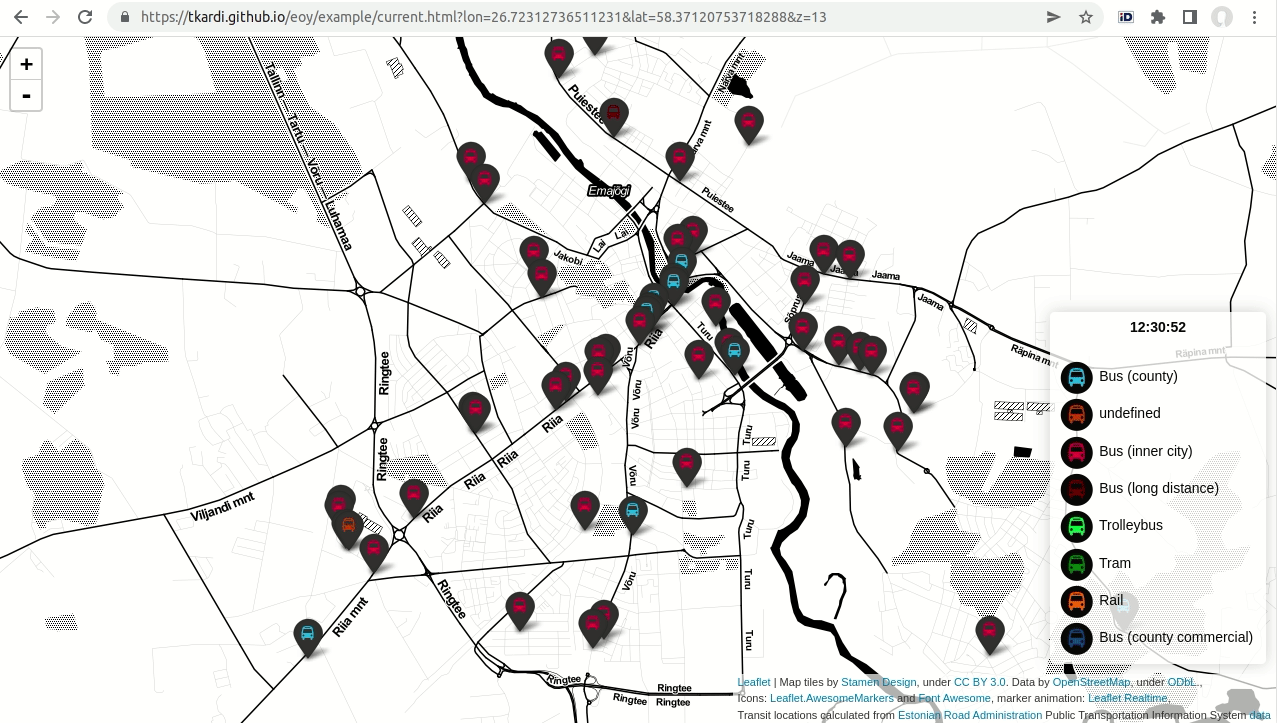
example dashboard and API
https://github.com/tkardi/eoy/tree/dockerize

the projection tango

madagascator
shift North Pole to the equator at -30W and rotate Madagascar northwards
              
                select
                    *


                from (
                    select
                        gid, (st_dumppoints(geom)).*
                    from
                        ne_10m_admin_0_countries ) f


                ;
              
            
st_dumppoints for all vertices
shift North Pole to the equator at -30W and rotate Madagascar northwards
              
                select
                    st_project(
                        st_setsrid(st_point(-30,0), 4326)::geography,
                        st_distance(st_setsrid(st_point(0,90),4326)::geography, geom::geography),
                        st_azimuth(st_setsrid(st_point(0,90),4326)::geography, geom::geography) - radians(125)
                    )::geometry(point, 4326) as geom,
                    row_number() over()::int as oid, gid, path
                from (
                    select
                        gid, (st_dumppoints(geom)).*
                    from
                        ne_10m_admin_0_countries ) f
                where
                    st_y(geom) >-88
                ;
              
            
st_project a new point ( geography ) with the old distance and azimuth (minus some whatever constant)
Based on NaturalEarth country boundaries, and proccessed in PostGIS using this SQL
Errr.... what about flatearthator?
Shift North Pole to Null Island and create the "ice wall"
              
                select
                    *


                from (
                    select gid, (st_dumppoints(geom)).*
                    from ne_10m_admin_0_countries
                ) f

                ;
              
            
st_dumppoints for all vertices
Shift North Pole to Null Island and create the "ice wall"
              
                select


                                    st_buffer(
                                        st_setsrid(st_point(0,0),4326)::geography,
                                        st_distance(st_setsrid(st_point(0,90),4326)::geography, geom::geography) / pi()
                                    )::geometry(polygon, 4326)


                from (
                    select gid, (st_dumppoints(geom)).*
                    from ne_10m_admin_0_countries
                ) f

                ;
              
            
st_project will not be of use here, let's pretend we're on a flat surface so st_buffer instead
Shift North Pole to Null Island and create the "ice wall"
              
                select


                            st_rotate(
                                st_exteriorring(
                                    st_buffer(
                                        st_setsrid(st_point(0,0),4326)::geography,
                                        st_distance(st_setsrid(st_point(0,90),4326)::geography, geom::geography) / pi()
                                    )::geometry(polygon, 4326)
                                ),
                                radians(90)
                            )


                from (
                    select gid, (st_dumppoints(geom)).*
                    from ne_10m_admin_0_countries
                ) f

                ;
              
            
Take the resulting st_exteriorring and st_rotate it 90 degrees counter-clockwise
Shift North Pole to Null Island and create the "ice wall"
              
                select

                        st_scale(
                            st_rotate(
                                st_exteriorring(
                                    st_buffer(
                                        st_setsrid(st_point(0,0),4326)::geography,
                                        st_distance(st_setsrid(st_point(0,90),4326)::geography, geom::geography) / pi()
                                    )::geometry(polygon, 4326)
                                ),
                                radians(90)
                            ), 1.70, 1.70
                        )


                from (
                    select gid, (st_dumppoints(geom)).*
                    from ne_10m_admin_0_countries
                ) f
                where st_y(geom) >-85 and st_y(geom) < 85
                ;
              
            
st_scale it a bit bigger, but keep in mind epsg:3857 bounds, and don't distort the output, let Mercator do it instead.
Shift North Pole to Null Island and create the "ice wall"
              
                select
                    st_lineinterpolatepoint(
                        st_scale(
                            st_rotate(
                                st_exteriorring(
                                    st_buffer(
                                        st_setsrid(st_point(0,0),4326)::geography,
                                        st_distance(st_setsrid(st_point(0,90),4326)::geography, geom::geography) / pi()
                                    )::geometry(polygon, 4326)
                                ),
                                radians(90)
                            ), 1.70, 1.70
                        ),
                        st_azimuth(st_setsrid(st_point(0, 90),4326)::geography, geom::geography) / (2*pi())
                    ) as geom, gid, path
                from (
                    select gid, (st_dumppoints(geom)).*
                    from ne_10m_admin_0_countries
                ) f
                where st_y(geom) >-85 and st_y(geom) < 85
                ;
              
            
And finally st_lineinterpolatepoint from the start of the exterior line to the fraction defined by st_azimuth between the North Pole and the original vertice.
Based on NaturalEarth country boundaries, and proccessed in PostGIS using this SQL
https://gist.github.com/tkardi/c295bbdcc2c7e21edb365fd3852894e9

#30DayMapChallenge

(on GitHub and Twitter)
A peek at weather forecast
(data courtesy of Estonian Environment Agency)

Unknown Pleasures by Joy Division
(and air temperature forecast)
image: beyondvinyl.co.uk
grid points to horizontal lines
              
                select


                                        st_force3d(
                                            st_point(
                                                x,
                                                y + temperature * 1000
                                            )
                                        )


                from (
                  select temperature, valid_from, valid_to, x, y from phenomen
                ) f
                ;
              
            
create a point (st_point) shifting its y coordinate to the north by coefficent of temperature, and st_force3d.
grid points to horizontal lines
              
                select


                                st_setsrid(
                                    st_translate(
                                        st_force3d(
                                            st_point(
                                                x,
                                                y + temperature * 1000
                                            )
                                        ), 0, 0, temperature
                                    ), 3301
                                )


                from (
                  select temperature, valid_from, valid_to, x, y from phenomen
                ) f
                ;
              
            
st_translate the points z-coordinate to the value of temperature, and st_setsrid to epsg:3301.
grid points to horizontal lines
              
                select

                        st_makeline(
                            array_agg(
                                st_setsrid(
                                    st_translate(
                                        st_force3d(
                                            st_point(
                                                x,
                                                y + temperature * 1000
                                            )
                                        ), 0, 0, temperature
                                    ), 3301
                                ) order by x
                            )
                        )

                from (
                  select temperature, valid_from, valid_to, x, y from phenomen
                ) f
                group by y, valid_from, valid_to;
              
            
st_makeline of all points on the same y
grid points to horizontal lines
              
                select
                    st_chaikinsmoothing(
                        st_makeline(
                            array_agg(
                                st_setsrid(
                                    st_translate(
                                        st_force3d(
                                            st_point(
                                                x,
                                                y + temperature * 1000
                                            )
                                        ), 0, 0, temperature
                                    ), 3301
                                ) order by x
                            )
                        ), 5
                    ) as geom, y, valid_from, valid_to
                from (
                  select temperature, valid_from, valid_to, x, y from phenomen
                ) f
                group by y, valid_from, valid_to;
              
            
apply st_chaikinsmoothing on the lines
What about assigning different colors to different temperatures on the same line?
(sure, why not but for that we'll need to ...)
split lines on every vertex for coloring
              
                with segments as (


                        select
                            oid, st_dumppoints(geom) as pt
                        from
                            chaikinlines_temperature

                )
                select
                    *
                from
                    segments

                ;
              
            
st_dumppoints for all points of st_chaikinsmoothing-ed lines.
split lines on every vertex for coloring
              
                with segments as (
                    select
                        st_makeline(
                            lag((pt).geom, 1, null) over(
                                partition by y, valid_from order by valid_from, y, (pt).path
                            ),
                            (pt).geom
                        ) as geom, valid_from, valid_to
                    from (
                        select
                            oid, st_dumppoints(geom) as pt
                        from
                            chaikinlines_temperature
                    ) as dumps
                )
                select
                    *
                from
                    segments
                where
                    geom is not null;
              
            
st_makeline of two consequtive points on the same y
split lines on every vertex for coloring
              
                with segments as (
                    select
                        st_makeline(
                            lag((pt).geom, 1, null) over(
                                partition by y, valid_from order by valid_from, y, (pt).path
                            ),
                            (pt).geom
                        ) as geom, valid_from, valid_to
                    from (
                        select
                            oid, st_dumppoints(geom) as pt
                        from
                            chaikinlines_temperature
                    ) as dumps
                )
                select
                    geom, st_z(st_lineinterpolatepoint(geom, 0.5)) as temperature, valid_from, valid_to
                from
                    segments
                where
                    geom is not null;
              
            
take the midpoint of the segment with st_lineinterpolatepoint and its (interpolated) st_z as temperature value
SQL bits and hi-fi version, animated with QGIS

Polyps
(and wind speed + direction forecast)
image: By [1], CC BY-SA 2.5, Link
Use ellipses:
- eccentricity for wind speed
- turn angle for wind direction
st_ellipse function off PostGIS User's Wiki
grid points to ellipses of sizes and directions
              
                select
                    *


                from (
                    select
                        st_transform(
                            st_project(
                                grid::geography, coalesce(wind_speed_mps,0)*500, radians(coalesce(wind_direction_deg, 0))-pi()
                            )::geometry(point, 4326),
                        3301) as geom, wind_speed_mps, wind_direction_deg, valid_from, valid_to
                    from
                        phenomen
                ) f;
              
            
shift grid point off its location by a factor of speed in the wind direction using st_project and then st_transform to epsg:3301
grid points to ellipses of sizes and directions
              
                select


                            st_ellipse(
                                st_x(geom), st_y(geom),
                                2500, 2500 + (coalesce(wind_speed_mps,0)*1000), 0, 16
                            )


                from (
                    select
                        st_transform(
                            st_project(
                                grid::geography, coalesce(wind_speed_mps,0)*500, radians(coalesce(wind_direction_deg, 0))-pi()
                            )::geometry(point, 4326),
                        3301) as geom, wind_speed_mps, wind_direction_deg, valid_from, valid_to
                    from
                        phenomen
                ) f;
              
            
create a st_ellipse in the previously shifted position with the longer axis as a factor of wind speed
grid points to ellipses of sizes and directions
              
                select
                    st_rotate(
                        st_setsrid(
                            st_ellipse(
                                st_x(geom), st_y(geom),
                                2500, 2500 + (coalesce(wind_speed_mps,0)*1000), 0, 16
                            ),
                            3301
                        ),
                        -1*(radians(wind_direction_deg) + pi()),
                        geom
                    ) as geom, wind_speed_mps, wind_direction_deg, valid_from, valid_to
                from (
                    select
                        st_transform(
                            st_project(
                                grid::geography, coalesce(wind_speed_mps,0)*500, radians(coalesce(wind_direction_deg, 0))-pi()
                            )::geometry(point, 4326),
                        3301) as geom, wind_speed_mps, wind_direction_deg, valid_from, valid_to
                    from
                        phenomen
                ) f;
              
            
st_rotate the ellipse in the desired direction anchoring on the shifted position.
SQL bits and hi-fi version, animated with QGIS
Globe
(me going full-on estonian)
SQL bits and hi-fi version, animated with QGIS
https://tkardi.ee/writeup/30daymapchallenge/
Spatial SQL is fun!
as well useful in real life
proceed to the directors cut
@tkardi
tonis.kardi@gmail.com
https://tkardi.ee